LIGHTHOUSE
| Location | 17-239 Dangsado-gil, Soan-myeon, Wando-gun, Jeollanam-do | |
|---|---|---|
| First day of beacon | February 1909 | |
| Light wave beacon | Type | RB90 (120V-500W) |
| Signal | 1 Flash of White light, 10 seconds (Fl W 10s) | |
| Range | Geographical 19 miles, luminous 43 miles, Nominal 26 miles | |
| Sound wave beacon | Type | KRB375(220V-700W) |
| Signal | Signal length 5 seconds, pause 50 seconds | |
-
Background of construction
- he Communications department under the Japanese Governor-General of Korea constructed the Dangsado lighthouse and endowed it with substantial illuminating power in JAN 1909. The lighthouse was erected south of Dangsado island to provide a navigational land aid for ships with displacement tonnage over 10,000 tons that sailed between Busan-Incheon and those that travelled from the Geomundo-Chungsando-Soan archipelago and Jeju waters towards Mokpo. During the Pacific War, the narrow waterway between the Soando, Bogildo and Nohwado was used as a strategic stronghold by naval vessels and the Dangsado lighthouse served as a major land aid to navigation.
-
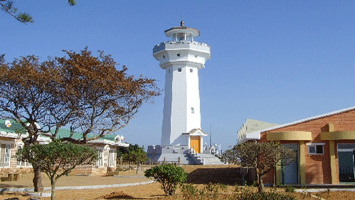
Structure and characteristics of the lighthouse
- Structure : An octagonal concrete structure with a helical ladder inside, and an additional ladder on the outside.
- Characteristics : Height of the lighthouse is 8.2m, and the lighthouse summit is 95m from mean sea level.
-
History
- Jan. 1909 : Jajido lighthouse, Lighthouse office at the Customs Department of the Korean Empire
- Dec. 1945 : Maritime department, Transport division of US Military Administration
- Dec. 1955 : Mokpo Regional Maritime Affairs Office
- Dec. 1977 : Jajido lighthouse, Mokpo Regional Maritime and Port Office
- Aug. 1988 : Navigational Beacon Management Office (renamed), Mokpo Regional Maritime Port Office
- May. 1997 : Jajido Navigational Beacon Management Office, Mokpo Regional Maritime and Fisheries Office
- Jan. 1999 : Dangsado Aids to Navigation management office, Mokpo Regional Maritime and Fisheries Office
- Mar. 2008 : Dangsado Aids to Navigation management office, Mokpo Regional Maritime Affairs and Port Office
-
Directions to the lighthouse
- By car and ferry
- Total route : Mokpo → Haenam land's end (Galdu-ri) → Imok-ri, Nohwa-eup, Wando-gun → Dangsado island → Dangsado Aids to Navigation management office
- Total distance : 151Km
- Total time to destination : 3 hours 10 minutes
- By car
- Route : Mokpo → Haenam land's end (Galdu-ri)
- Distance : 90Km
- Time to destination : 1 hour 30 minutes
- By ferry
- Route : Haenam land's end (Galdu-ri) → Imok-ri, Nohwa-eup, Wando-gun
- Distance : 53Km
- Time to destination : 1 hour
- Inquiries : 061) 533-4269 (Galdu-ri passenger ferry terminal)
- Route : Imok-ri, Nohwa-eup, Wando-gun → Dangsado island
- Distance : 8Km
- Time to destination : 40 minutes
- Inquiries : 061) 553-8086 (Dangsado Aids to Navigation management office)
- * Ferry timetable may change due to weather conditions
- By car and ferry
-
Caretaker status
- No. of caretakers : 3 caretakers
- Duty rotation : 3 shift rotation in 24 hours
- Nearby attractions : Dorisan mountain pavilion observation deck, Gwanmaedo island,Shinjeon beach